It is well known that pelagic fishes like tunas and marlin will often frequent areas where their feed is concentrated. How can you find these areas? Flocks of feeding seabirds are a good indicator of the presence of feed at the surface, but there are often areas with feed that the birds have not found, or the feed may not be close enough to the surface for the birds to capture them. The birds might also have fed and left an area. So birds and feed is not a one-to-one relationship. There are other methods that can be used to define the areas where feed is likely to be found, even if there are no birds around.
The pattern of feed in the ocean is patchy, which in the simplest terms means it is only present at some locations and at some times, and both the locations and times change. The location of feed patches varies both horizontally and vertically. The timing for feed patches is influenced by short-term variability due to tidal flow which has an approximate half-day cycle, and by the vertical swimming behaviour of the plankton which changes over a day-night cycle. Feed distribution varies with the wind because it mixes the surface of the ocean, and this weather-scale is days to weeks. From the weekly to the seasonal time scale, the warming of the ocean surface by the sun affects how deeply the wind mixes the surface water. When the sun warms the surface of the ocean, the water becomes less dense as the temperature rises, and less dense water forms a stable cap on the cooler, denser water below. When the wind rises again, this warm water is mixed down into the cooler water. The depth to which this mixing extends is called the Mixed Layer Depth. It has a formal definition in oceanography, but you don’t need to worry about that.
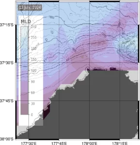
Why would fishers want to know about Mixed Layer Depth? In a nutshell, when the mixed layer is shallow, the nutrients in the cooler, deeper water come close to the surface, and this fuels rapid growth of the phytoplankton in the sunlit surface of the ocean. Phytoplankton are the tiny plants of the ocean which contain a pigment called chlorophyll. The phytoplankton grow quickly and can double in concentration in one to two days. These minute particles are eaten by zooplankton which are equivalent to the insects on land. The zooplankton grow more slowly than the phytoplankton, but smaller zooplankton can still double in number as quickly as 4 days to a week. The zooplankton include a whole range of different sized, small animals, going up to as large as krill, the shrimp-like creatures that many fishers will be familiar with finding in the stomachs of fish. Squid and baitfish such as anchovies feed on the zooplankton, and sardines (or pilchards) filter feed on the phytoplankton. Mackerels feed on the sardines, anchovies, squid, and krill, as well as consuming juveniles fishes and fish eggs. Squid are voracious feeder on krill and baitfish.
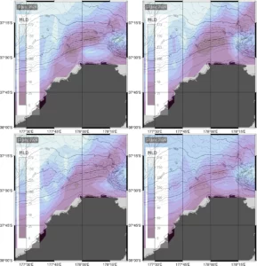
When the mixed layer is shallow and stable, the growth of the phytoplankton supports a rapidly growing food web in the sunny, warm cap of water sitting on top of the cooler, nutrient-rich deeper water. These productive patches of water have the potential to support concentrations of feed, but the concentrations take time to develop. Areas of shallow mixed layer that have persisted for at least four days to a week are likely to be feeding areas for the large pelagic fishes like dorado, tuna, and marlin.
In this blog I explained why Mixed Layer Maps are useful for locating areas likely to support concentration of feed. Like any of the other variables, Mixed Layer Depth is not the whole story, but can be used with the SST, chlorophyll, current, and bathymetry maps to help locate favourable areas for big game fish.