What are temperature breaks, or fronts?
Fronts are areas where waters of different properties meet and mix in complex ways. Everyone knows that temperature breaks, or fronts, are areas where warm and cool water meet. What is not so well known is that these areas can be associated with complex vertical and horizontal flows at small scales that don’t show up on the currents maps provided by gamefishing apps. If you think of the water meeting at fronts as distinct layers, the less dense warmer or fresher water will naturally lie above cooler, saltier water layers, because less dense water lies on top of denser water. Small-scale flows can produce interleaving of these water layers. Where the layers meet, they tend to mix at the interface. As the layers slide past each other, the sliding creates friction, or shear. The shear drives mixing between the layers. The shear also causes the layers to distort. Think of how thick cream stirred into black coffee mixes in a pattern of stringy swirls. The distortion of the water layers is called strain. Patterns of shear and strain, and the associated mixing vary in intensity along the frontal boundary.
Fronts accumulate plankton in ways that may surprise you. The accumulation of plankton in temperature breaks, or fronts, is complicated by several factors. Mixing of surface and subsurface water at fronts due to vertical shear can lead to nutrient enrichment. More nutrients favours the growth of phytoplankton, the single celled plants of the ocean that are often indicated by their chlorophyll content. If fronts persist, phytoplankton will grow and accumulate in these nutrient enriched waters. However recent work showed that the accumulation of plankton in fronts is due more to entrainment and flow along the fronts rather than to growth within the front. Entrainment is when a flow pulls more water into the flow, like a pipe outfall entering into a stream. Here the front is acting as a conduit to move phytoplankton from more productive water in horizontal currents along the front, rather than the phytoplankton growing up within the frontal region. This happens along the California coast, for example, when upwelled water is pulled offshore in streamers or jets that look like rivers in SST images. It also happens when swirling eddies (rotating bodies of water) entrain water into their rotation to create fronts at their edges.
Why are fronts important?
Fronts create a feast of plankton that is enriched every night and fades during the day. Accumulations of phytoplankton in fronts provide a food source for zooplankton, which can be thought of as the insects of the oceans (they are actually crustaceans, not insects). Zooplankton that feed on the phytoplankton move vertically in the water column in a daily cycle called diel vertical migration. They arrive at the surface at night to feed on the phytoplankton, and descend again at dawn to deeper depths where they are less visible to their own predators. Krill, squid, and small mesopelagic fishes, which are called nekton, also actively vertically migrate each day and night, feeding on the zooplankton. These animals form scattering layers, often referred to as feed layers, that can be picked up on the higher frequencies of an echosounder. Through this combination of processes, areas with strong fronts that persist over several days provide concentrated food patches both at the surface, and deeper in the water column.
Fish search for the fronts, and then modify their behaviour to exploit the plankton and feed in the most energy-efficient ways. Game fish like albacore move along the fronts, keeping their muscles active in the warmer side of fronts, and crossing over to feed on the cooler side (see this blog for more detail: https://www.fishingmaps.info/articles/tuna-and-temperature-breaks/). Predators like marlin and tunas can swim much faster than the currents, but there is increasing evidence that they actively swim to search for frontal areas, and then drift with the currents when they find feed concentrations. They conserve the energy that would be expended in searching by drifting with the current, and redirecting their energy toward diving and feeding in the scattering layers. Frontal areas are important feed concentration areas that gamefishers can target, but this raises the question of how best to detect them.
How to target the SST breaks in Fishing Maps
Look for breaks that persist over time using the 4-day maps
Fronts move, and the accumulation of plankton takes several days, so the balance between these two processes determines whether there will be a feed for game fish. You will be more successful targeting on temperature breaks if the fronts have been consistent in an area for several days. To determine whether this is the case, look at the 4-day maps for your region. There is also a time lag for the satellite data. Even the 3-hourly SST data are not instantaneous, and fronts can move by the hour. Expecting to find a front exactly where the latest satellite image says it is is unrealistic. Targeting a frontal zone where temperature breaks have been observed consistently over several days is a more reasonable approach. When you add the fact that fish search for fronts and drift with the fronts when they find them, it becomes even more evident that targeting persistent frontal zones rather than targeting individual front edges is likely to be a better strategy.
Focus on the strongest temperature breaks
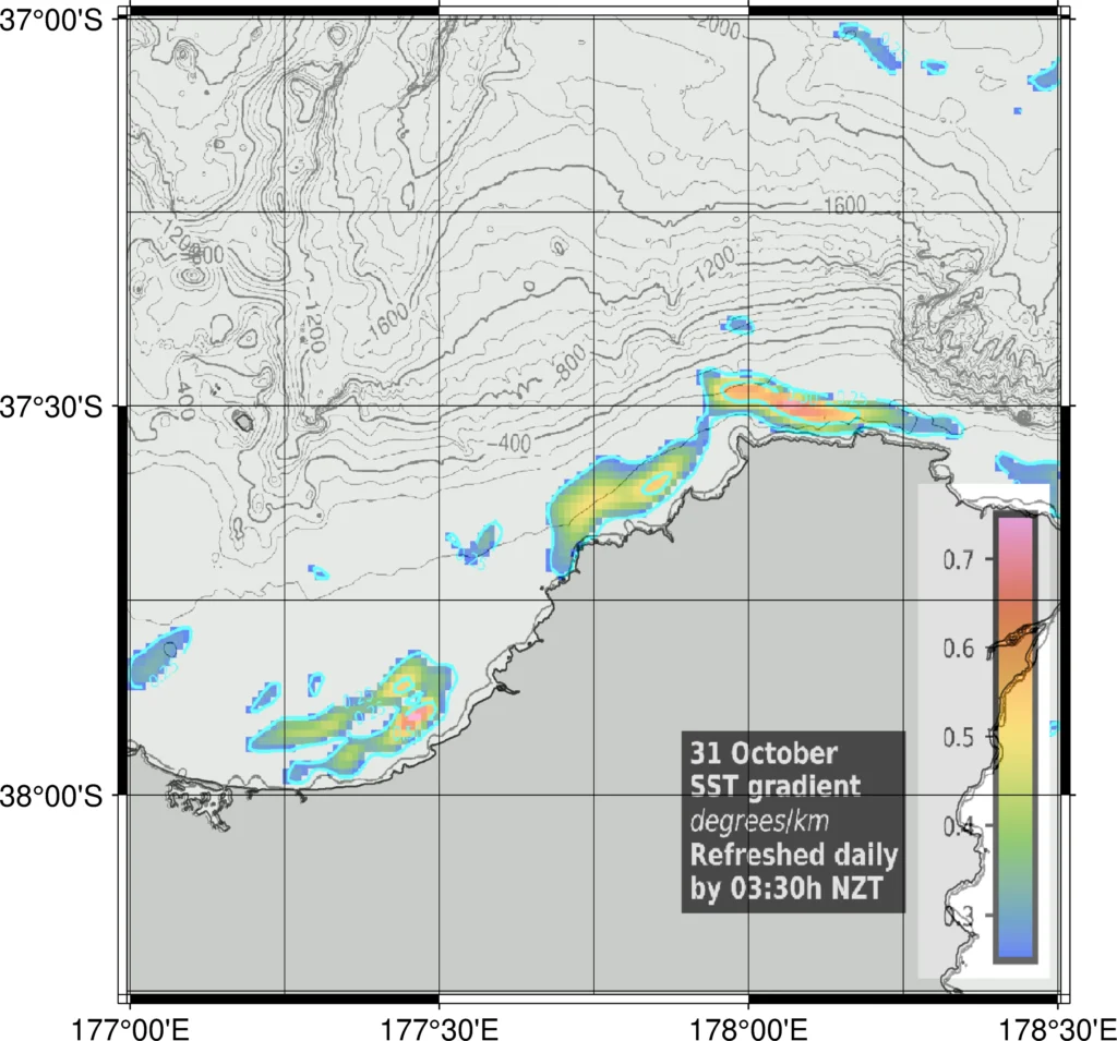
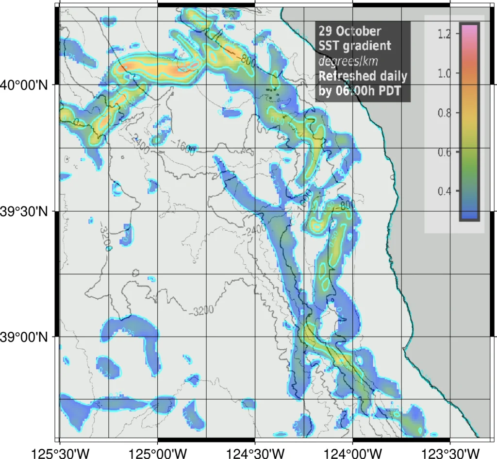
The maps show the size of the SST gradient, which is an objective measure of the strength of the temperature breaks. I have thresholded the data to show only the strongest breaks. Use the colour bar to select the breaks that have the strongest gradient (red on the colourbar). Notice that the strength of the breaks varies along a front.
Figure 1 shows temperature breaks that have formed close to shore in the eastern Bay of Plenty, off Waihau Bay, and off Lottin Point, in New Zealand. The breaks off Waihau Bay and Lottin Point lie along the 100 depth contour. The temperature gradients show that the most extensive and strongest breaks are of Lottin Point (Figure 1). The colourbar makes it easy to see where the strongest breaks are because they are coloured red. Figure 2 shows temperature breaks off Fort Bragg, northern California. Most of the breaks are oriented alongshore, but the strongest breaks indicated by the red colours, are orientated across-shore. In both cases it is very clear where the fronts are, and where the strongest temperature breaks can be found along the fronts.


Look at how the breaks relate to other information in the maps
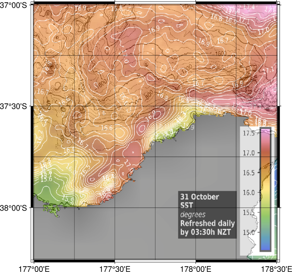
Temperature breaks are not the whole story when it comes to using satellite maps for targeting game fish, but they are a very good start. It is useful to compare the temperature break maps to the SST maps to see the distribution of water temperatures on either side of the temperature breaks. Comparing Figure 1 and Figure 3 shows that the temperature break at Lottin Point brings the warmest surface water in the region at this time very close to shore where it forms a strong temperature break with coastal water that is 1.5 degrees C cooler.
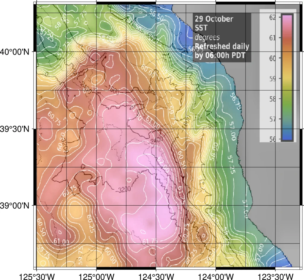
The situation off Fort Bragg, California is quite different (compare Figure 2 and Figure 4). The fronts have formed at the periphery of a large warm patch of water with a temperature of 62 degrees F that is lying offshore. Fronts have formed on the eastern and northern side of the patch, with the most intense breaks on the northern edge. The water inshore of the fronts is about 5 degrees F cooler than the offshore water.


The bottom line
The bottom line for gamefishers is that the SST breaks map provides an objective and uncluttered view of where the temperature breaks are, how persistent they are over several days, and where the most intense breaks lie. Comparing the persistent and intense temperature breaks with the other maps, especially the SST map allows fishers to determine if the fronts lie adjacent to water that is a suitable temperature for their target species. Further comparisons with the bathymetry map and the chlorophyll map will add even more information when deciding if a persistent frontal zone is likely to be a good area to target.
