Fishers often compare the temperature measured from their boat with the satellite-derived Sea Surface Temperature (SST) in the same area. Sometimes the measurements are close, and sometimes the measurements differ by several degrees. When the measurements differ, it can be tempting to assume that the SST is not accurate. The problem is that the two measurements are not the same, so a direct comparison between boat temperature and SST is like comparing apples with oranges. Both measurements may be accurate even when they are different.
Let’s look into the details to see how that could be true. The upper surface of the ocean has a complicated temperature structure, even in the top few meters. The temperature in the near-surface layer is affected by solar heating, and by mixing, which is driven by wind and waves. If the surface water is stirred by the wind and there is no heating by the sun, which is the case at night, the surface temperature will be more homogeneous. This means that the boat temperature and SST will be very close at night, or if it is windy. However, during a sunny day, especially if it has been calm, the surface of the ocean will warm, and the warm near-surface layer will not be mixed by wind-driven stirring with the cooler water below. This is why the SST can be warmer than the boat temperature under sunny, calm conditions.
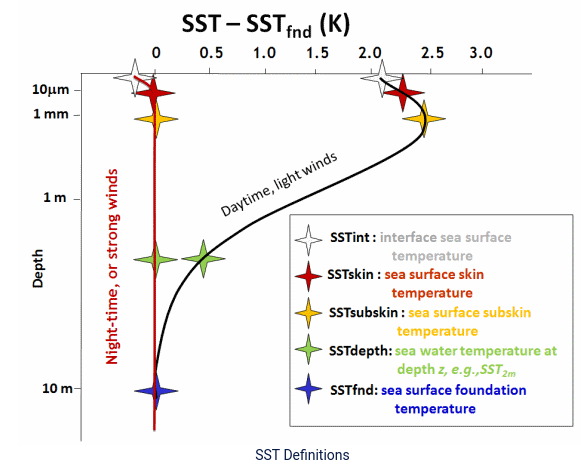
SST is what is called a surface skin temperature. The temperature is measured by spectroradiometers and radiometers and infrared sensors on several satellites, and these measurements are combined with in situ measurements from the upper few meters of the water column to produce a melded SST product. The SST measurements are dominated by the temperature in the upper few millimeters of the ocean, and this skin layer of the ocean is subject to surface heating during the daytime, as shown in the graph above (Figure 1). In contrast to SST, boat temperature sensors are often at 0.5 to 1 meter depth, sometimes mounted on the acoustic transducer which is positioned to be below most of the bubbles generated by the boat hull. As shown in the graph above the water temperature at 1 meter can be about 1 degree Celcius (or 1.8 degrees Fahrenheit) cooler than in the top few millimeters of the ocean on sunny, calm days. So the boat temperature will then be cooler than the satellite SST.
The next question is whether the SST and boat temperatures are accurate. SST products produced by NASA, NOAA and the European Space Agency are carefully calibrated and tested. All of the methods, algorithms (or procedures) and calculations that go into producing these products are fully documented in literally hundreds of reports and peer-reviewed publications written by experts (too numerous to cite here). These publications are freely available on the Internet, so that the methods are transparent. There is no doubt that the SST products produced by these agencies are accurate.
The accuracy of boat sea surface temperatures is another matter. The sensors on fishing boats may be accurate at the time that they are installed, but most sensors experience drift with age, unless they are adjusted by re-calibration during maintenance. There is a range of additional factors that can influence the accuracy of boat sea surface temperatures, including where the sensor is mounted, the type of mounting, whether the sensor is in a sea chest or not, and speed of the boat at the time the measurement was taken (see Hendricks 2016 in References). It would be risky to assume that boat sea surface temperature provides the only accurate temperature measurement.
Key Points
- Satellite SST and boat SST will agree closely (assuming accurate boat temperature measurement) at night, or when it is windy.
- SSTs will be warmer than boat sea surface temperatures during the day when it is sunny and calm, due to the effect of surface heating on the surface skin of the ocean.
- Satellite SST products from NASA, NOAA and the European Space Agency are rigorously calibrated, fully documented and accurate.
- Boat sea surface temperatures may or may not be accurate.
- Both satellite SST and boat sea surface temperature can be correct and yet different at the same time.
References
Hendricks, J. 2016. Using Sea-Surface-Temperature Instruments. Saltwater Sportsman.